
HISTORY OF ALAÇATI
In 16th century, Çeşme region was the passageway where the Anatolians used for export. Especially Genoese tradesmen were settled in the Khios island opposite Çeşme. After the Ottomans occupied Khios Island in 1556, Çeşme handed over the trade superiority to İzmir, which was a small trade center where only western Anatolian products were sold. The silk that was produced in Bursa, which was the main silk production center in Anatolia, used to be transported to Khios from Çeşme until İzmir port became the center of export and trade.
In the 1980s, the south of Alaçatı used to be a swamp. The grand vizier of that time ordered his men to dry the swamp, so a canal was formed that ended up in the natural port in the south of Alaçatı. The swamp was dried by providing drainage from the lowlands using large ditches. The canal that was formed later became so big that it became a port where ships dock. Hacı Memiş Ağa, who was the senator of the time, led the work and brought Greek workers from the islands for the task.
The Greek workers who came to Alaçatı settled 100kms north of Alaçatı port and built the ‘new Alaçatı’. Since they did not have any lands to plough, Tukish owners of great lands lend some parts of their farmlands to Greek workerss to plough and then return to the owners. This was in a way the ‘build-operate-transfer’ model. The Greeks then develop vine growing in Alaçatı.
However, when the time comes to return the lands, the ‘Postov Event’ breaks out and the Greeks do not pass on their lands back to Turks.
So in 1873, Alaçatı Muncipality Organisation was founded. Around 19th century, 45.000 residents lived in and around Alaçatı, including Çeşme, Köste, Çiftlik, Ovacık and etc., 40.000 of which are Greeks and remaining 5000 Turks.
Starting from a hundred years ago, wine has been exported to countries abroad from Alaçatı. Wine of Alaçatı is considered to be one of the best quality wines in the world. That is why, most common decorative figures in Alaçatı churches are the grapevines.
Alaçatı’s destiny changed with the Balkan War in 1912. The first immigrants escaping from the commotion in Balkans, especially from Yugoslavia and Macedonia regions, arrived at Çeşme by ships and settled in Alaçatı. The arrival of these immigrants created panic among the Greeks and they soon left the region. Once again, in May 15, 1919, after İzmir was occupied by Greek armies, the Balkan immigrants who moved inland towards Uşak, Kütahya, Afyon and Konya, were replaced by the Greek immigrants.
With the start of the Great Offensive and the end of Greek occupation, Balkan immigrants come back to Alaçatı in November 1922, and the Greeks return to the islands. In the meantime, in January 30, 1923, Laussanne Treaty was signed between Greece and Turkey. With this Treaty, the Muslim settlers in Greece return to Turkey, and Orthodox Greeks settled in Turkey return to Greece – except for the Orthodox Greeks in İstanbul and Muslims in West Thrace. This way, immigrants from Salonika, Machiavelli, Crete and Kos settle in together with Albanian and Bosnian immigrants who moved to Alaçatı from Kosovo and Bosnia during Balkan War. The population of Alaçatı changed completely once more in a period of less than 10 years.
With the vine growing and wine production during Greek settlement, Alaçatı had one of the most glorious periods of its history. However, after the war, the situation began to decline. Since the Muslim Turks who came from the Balkans did not know anything about vine or olive growing, the vineyards in Alaçatı were removed and tobacco was grown by the immigrants from Salonika. Immigrants from Kosovo and Bosnia did what they know well, which is raising livestock.
In the 1980s, the main source of income was melon, onion, and growing of other fruit and vegetables and raising livestock – tobacco and anise planting being the most important. Later on, agriculture was replaced by trade and fishing, and that was carried on till today.
GEOGRAPHICAL FEATURES AND NATURAL STRUCTURE
Alaçatı is 79kms from İzmir and 7kms from Çeşme, and is located on a shoulder of Koca Dağ Mountain towards the west, between Ilıca (north) and Alaçatı Port (south). Its borders end at Aegean Sea and Çeşme in the west and at the town of Urla and Uzunkuyu woods in the east. The elevation is 16m above sea level and the area is 55km2. There are three villages in the province of Alaçatı. There is a white and yellow marl layer under the 0.5-1.0m thick ground cover. The town is surrounded by white limy marl and chalk.
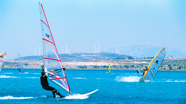
Karadağ Mountain which borders Çeşme from the west is a dormant which is rich in thermal resources. Around the village center, there are small creeks which carry the rain water. The Alaçatı Kutlu Aktaş Dam was built on Buca Lowland in 1998 and it provides drinking water. The rich soil of the area allows the growth of especially olive, anise, onion and artichoke. The natural Alaçatı port in the south is one of the best centers for windsurfers with its constant strong wind and still sea. The area has all the characteristics of Mediterranean climate. Winters are rainy – and summers are hot and dry. The population of Alaçatı differs according to season. Population is 10.000 in winter whereas 40-50 thousand in summer.